George Kendall Riverside Park
Parks for People
-
- A Metropolis of Three Cities
-
- Bankstown
- Bayside West Precincts
- Burwood, Strathfield and Homebush
- Camellia-Rosehill
- Carter Street
- Cherrybrook Precinct
- Church Street North
- Circular Quay Renewal
- Explorer Street, Eveleigh
- Frenchs Forest
- Greater Parramatta and Olympic Peninsula
- Greater Penrith to Eastern Creek
- Hornsby
- Independent Community Commissioner
- Ingleside
- Macquarie Park
- Narrabri
-
- North West Growth Area Implementation Plan
- Alex Avenue
- Box Hill and Box Hill Industrial
- Colebee
- Marsden Park Industrial
- Marsden Park North
- Marsden Park
- North Kellyville
- Riverstone East
- Riverstone Town Centre
- Riverstone West
- Riverstone
- Schofields Town Centre
- Schofields
- Shanes Park
- Tallawong Station
- Townson Road
- West Schofields
- Historical documents
- Northern Beaches Aboriginal Land
- Orchard Hills
- Parramatta CBD
- Penrith Lakes
- Pyrmont Peninsula
- Rhodes
- Riverwood
- Seven Hills
- South Eveleigh Train Workshop
- Telopea
-
- Aerotropolis Core, Badgerys Creek and Wianamatta-South Creek precincts
- Agribusiness precinct
- Luddenham Village Interim Strategy
- Master planning in the Aerotropolis
- Northern Gateway precinct
- The planning pathway
- Western Sydney Aerotropolis Development Control Plan
- Western Sydney Aerotropolis Explanation of Intended Effect
- Western Sydney Aerotropolis explained
- Westmead
- Wianamatta South Creek
-
- Technical assurance panel
- Urban Design for Regional NSW
-
-
- Artificial Intelligence in NSW Planning
- Assessment reports independent review
- Design guidance
- Environmental Impact Statement guidelines
- Environmental matters
- Faster Local Assessment Grant Program
- Geographic areas
- Sydney Planning Panels
-
-
- Business parks
- Commercial activity and outlook
-
- Central Coast Employment Land Precincts Map
- Central Coast Total Employment Lands Map
- Greater Sydney Employment Land Precincts Map
- Greater Sydney Total Zoned Employment Lands Map
- Hunter Metro Region Total Zoned Employment Lands Map
- Hunter Region Total Zoned Employment Lands Map
- Illawarra-Shoalhaven Region Total Zoned Employment Lands Map
- Regional NSW Zoned Employment Lands Map
- Planning performance
- Urban Development Program
-
-
- Advertising and signage
- Alpine resorts
- Building systems circulars
-
- Apartment Design Guide
- Better apartments
-
- Boarding houses and co‑living housing
- Build-to-rent housing
- Caravan parks, manufactured home estates and moveable dwellings
- Group homes
- In-fill affordable housing
- Retention of existing affordable housing
- Secondary dwellings
- Seniors housing
- Social and affordable housing
- Supportive accommodation and temporary housing
-
- Bayside Council’s housing snapshot
- Blacktown Council’s housing snapshot
- Blue Mountains Council’s housing snapshot
- Burwood Council’s housing snapshot
- Camden Council’s housing snapshot
- Campbelltown Council’s housing snapshot
- Canada Bay Council’s housing snapshot
- Canterbury-Bankstown Council’s housing snapshot
- Central Coast Council’s housing snapshot
- Cessnock Council’s housing snapshot
- Cumberland Council’s housing snapshot
- Fairfield Council’s housing snapshot
- Frequently asked questions
- Georges River Council’s housing snapshot
- Hawkesbury Council’s housing snapshot
- Hornsby Council’s housing snapshot
- How we developed the targets
- Hunters Hill Council’s housing snapshot
- Inner West Council’s housing snapshot
- Kiama Council’s housing snapshot
- Ku-ring-gai Council’s housing snapshot
- Lake Macquarie Council’s housing snapshot
- Lane Cove Council’s housing snapshot
- Liverpool Council’s housing snapshot
- Maitland Council’s housing snapshot
- Mosman Council’s housing snapshot
- Newcastle Council’s housing snapshot
- North Sydney Council’s housing snapshot
- Northern Beaches Council’s housing snapshot
- Parramatta Council’s housing snapshot
- Penrith Council’s housing snapshot
- Port Stephens Council’s housing snapshot
- Randwick Council’s housing snapshot
- Ryde Council’s housing snapshot
- Shellharbour Council’s housing snapshot
- Shoalhaven Council’s housing snapshot
- Strathfield Council’s housing snapshot
- Sutherland Council’s housing snapshot
- Sydney Council’s housing snapshot
- The Hills Council’s housing snapshot
- Waverley Council’s housing snapshot
- Willoughby Council’s housing snapshot
- Wollondilly Council’s housing snapshot
- Wollongong Council’s housing snapshot
- Woollahra Council’s housing snapshot
- Inland Code
- Social housing
-
-
-
-
- A sensory explosion
- Bowraville Children’s Playspace
- Civic Park Playspace, Warragamba
- Cook Reserve Playspace
- Livvi’s Place, Wagga Wagga
- Livvi’s Place, Warragamba
- Lot Stafford Playspace
- Masterplanned communities
- Melaleuca Village Lake Playspace
- Muston Park Playspace
- St Peters Fences Playspace
- Ten simple tips for more inclusive playspaces
- Town Beach Playspace
- Tumbalong Park Playspace
- Waitara Park Playspace
- Wild Play Garden
- Everyone Can Play grant
- Our principles
-
- Synthetic turf study
- NSW regional outdoor survey
- The Greater Sydney Outdoors Study
-
- News
Park upgrades - coming soon
We are working closely with the City of Parramatta to improve the much-loved George Kendall Riverside Park. Construction for the revitalisation of the park started in August 2023 with estimated completion mid 2024.
Following 3 rounds of community engagement (PDF, 3.4 MB), site studies, technical investigations and design work, the final concept design (PDF, 5.1 MB) and concept plan revised map (PDF, 3.6 MB) for the park are now complete and available.
About the park
George Kendall Riverside Park is a popular destination for the local community. The park’s wide-open spaces and connection to the river provide a place of respite in one of Sydney’s fastest growing regions.
During 3 rounds of engagement the community highlighted opportunities to make the park more exciting. They wanted a park with playful activities that welcomes all to enjoy the benefits of connecting with nature.
The final concept design leverages the unique location by the Parramatta River. Pathways will bring people down to the waters’ edge, and lead to a new hilltop lookout which will allow visitors to fully appreciate views of the river and beyond.
Parkgoers will be encouraged to explore the foreshore with nature trails and traverse the site through a series of connections including a recreation loop.
Accessibility has been addressed by integrating the site with the Parramatta River Cycleway and creating a new arrival space with parking to bring people into the park.
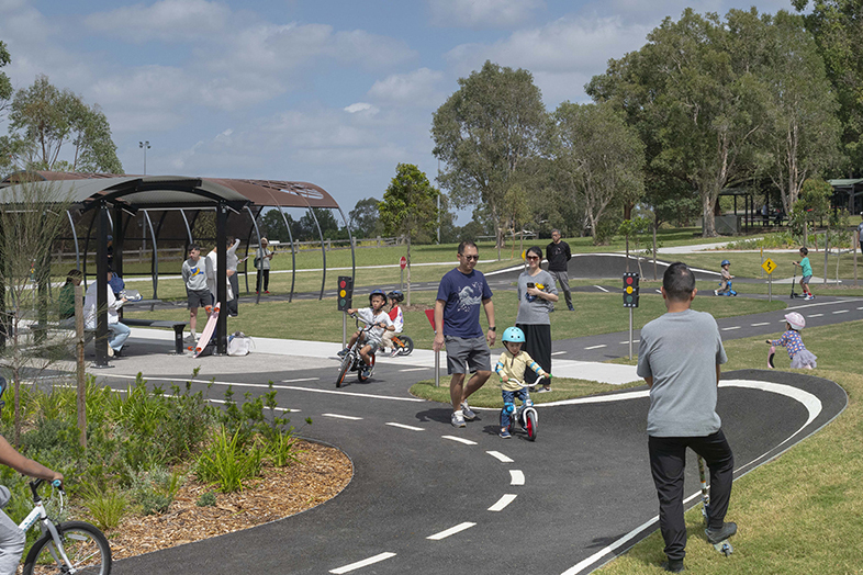
A learn-to-ride space aimed at young children, creating a family destination has been integrated into the existing playspace.
We will enhance the site's connection to nature with a new, constructed wetland to filter and capture stormwater and new tree planting for shade all year round. Remediation will occur for the site's landfill.
These planned upgrades will not only create a more playful and enjoyable experience, but will enable the park to better accommodate the growing demand for open space in Ermington.
Go to Parks for People for more information about the program.
Design process
-
Step 1
The first step was to find out what can and can’t be done on the site through due diligence studies and consultation with industry and local experts. The top priority was to create a fun place for diverse recreational interests, ages, and abilities, and to celebrate the natural landscape.
-
Step 2
We sought initial ideas and feedback from the community and key stakeholders to inform the development of a draft concept design for the upgrades.
-
Step 3
We presented a draft concept design for community feedback and further input before developing more detailed designs for the park. This stage included a design board to allow people to take a closer look at the proposed key features of the park, and a survey to capture community priorities and values that needed to be further represented in the final plan.
-
Step 4
We provided an opportunity for the community to take a detailed look at the final plan for the upgrades to George Kendall Riverside Park.
Frequently asked questions
Where is the park located?
George Kendall Riverside is a large park that follows the Parramatta River on the Ermington side of the Silverwater Bridge.
Why upgrade George Kendall Riverside Park?
The park is within the Parramatta area - Sydney’s second central business district and the fastest growing local government area in New South Wales. It is well loved and well used by the community, attracting locals and visitors who relax, play, cycle, walk and enjoy the open spaces, mangroves and river. It’s also an important habitat for wildlife.
As the community continues to grow, and the park gets busier, the upgrades will ensure the space can preserve its natural setting while supporting a diversity of uses and creating special experiences for all members of the community.
How will the park be upgraded?
The upgrades respond to community feedback and include:
- Greater access to the river with foreshore nature trails and recreation loop
- New hilltop lookout
- Integration of the site with the Parramatta River Cycleway, including upgrades to the pathway, and creation of a new arrival space with parking to bring people into the park
- Remediation of the site's historical use as landfill, particularly the dog park, removal of leachate pipes and capping layer under wetland.
- A learn-to-ride space aimed at young children, integrated into the existing playspace
- Greater connection to nature with a new, constructed wetland and swale to filter and capture stormwater and new tree planting for shade all year round.
- New vehicle entry and car park with pedestrian access and upgraded road and signage
- Upgraded off-leash dog area.
Construction started in August 2023.
Who was involved in the design of the park upgrades?
The design for the George Kendall Riverside Park upgrades was done in close collaboration with the City of Parramatta, the local community, key stakeholders, and experts.